Learn About The Law
Get help with your legal needs
FindLaw’s Learn About the Law features thousands of informational articles to help you understand your options. And if you’re ready to hire an attorney, find one in your area who can help.
Current as of January 02, 2025 | Updated by Findlaw Staff
1. Phase I inspections are not intended to provide detailed hydrologic and hydraulic analyses of dam and reservoir capabilities. However, when such analyses are available, they should be evaluated for reliability and completeness. If a project's ability to pass the appropriate flood (see Table 3, page D–12 of Recommended Guidelines) can be determined from available information of a brief study, such an assessment should be made. It should be noted that hydrologic and hydraulic analyses connected with the Phase I inspections should be based on approximate methods or systematized computer programs that take minimal effort. The Hydrologic Engineering Center (HEC) has developed a special computer program for hydrologic and hydraulic analyses to be used with the Phase I inspection program. Other Field Operating Agencies have developed similar computer programs or generalized procedures which are acceptable for use. All such efforts should be completed with minimum resources.
2. A finding that a dam will not safely pass the flood indicated in the Recommended Guidelines does not necessarily indicate that the dam should be classified as unsafe. The degree of inadequacy of the spillway to pass the appropriate flood and the probable adverse impacts of dam failure because of overtopping must be considered in making such classification. The following criteria have been selected which indicate when spillway capacity is so seriously inadequate that a project must be classified as unsafe. All of the following conditions must prevail before designating a dam unsafe:
a. There is high hazard to loss of life from large flows downstream of the dam.
b. Dam failure resulting from overtopping would significantly increase the hazard to loss of life downstream from the dam from that which would exist just before overtopping failure.
c. The spillway is not capable of passing one-half of the probable maximum flood without overtopping the dam and causing failure.
3. The above criteria are generally adequate for evaluating most non-Federal dams. However, in a few cases the increased hazard potential from overtopping and failure is so great as to result in catastrophic consequences. In such cases, the evaluation of condition 2c should utilize a flood more closely approximating the full probable maximum flood rather than one-half the flood. An example of such a situation would be a large dam immediately above a highly populated flood plain, with little likelihood of time for evacuation in the event of an emergency.
4. Conditions 2a and 2b require an approximation of housing location in relation to flooded areas. Resources available in Phase I inspections do not permit detailed surveys or time-consuming studies to develop such relationships. Therefore, rough estimates will generally be made from data obtained during the inspection and from readily available maps and drawings. Brief computer routings such as the HEC–1 dam break analysis, using available data, are recommended in marginal cases. The HEC–1, dam break version, is available on the Boeing Computer Services or may be obtained from the Hydrologic Engineering Center, Davis, California. Available resources do not permit detailed studies or investigations to establish the amount of overtopping that would cause a dam to fail, as designated in condition 2c. Professional judgment and available information will have to be used in these determinations. When detailed investigations and studies are required to make a reasonable judgment of the conditions which designate an unsafe dam, the inspection report should recommend that such studies be the responsibility of the dam owner.
5. During the inspection of a dam, consideration should be given to impacts on other dams located downstream from the project being inspected. When failure of a dam would be likely to cause failure of another dam(s) downstream, its designation as an unsafe dam could result in multiple impacts. Therefore, the information should be explicitly described in the inspection report. Such information may be vital to the priorities established by State Governors for dam improvements. Similarly, when the failure of an upstream dam (classified as unsafe) could cause failure of the dam being inspected, this information should be prominently displayed in the inspection report.
6. The criteria established in paragraph 2 for designating unsafe dams because of seriously inadequate spillways are considered reasonable and prudent. They provide a consistent bases for declaring unsafe dams and also serve as an effective compromise between the Recommended Guidelines and unduly low standards suggested by special interests and individuals unfamiliar with flood hazard potential.
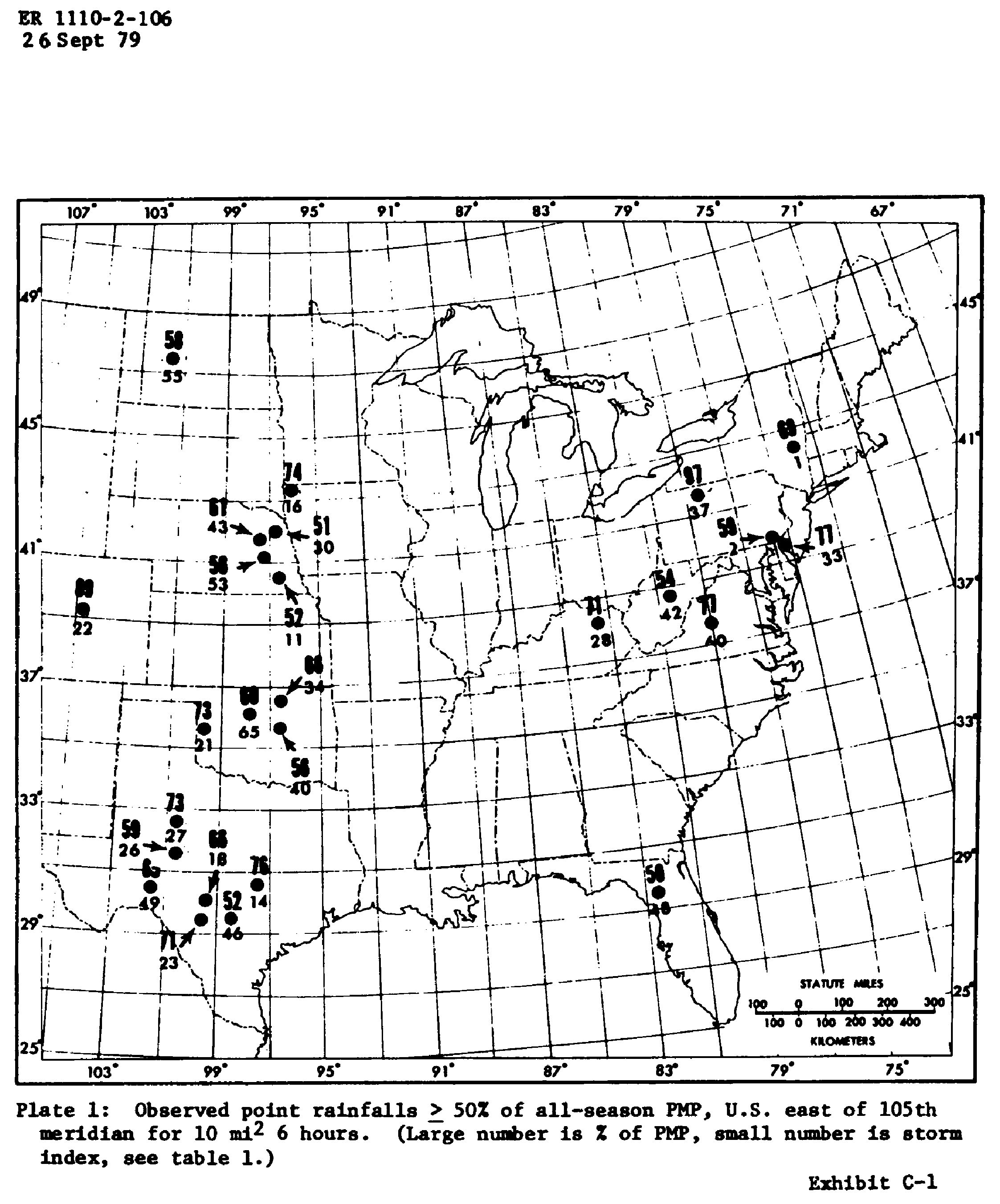
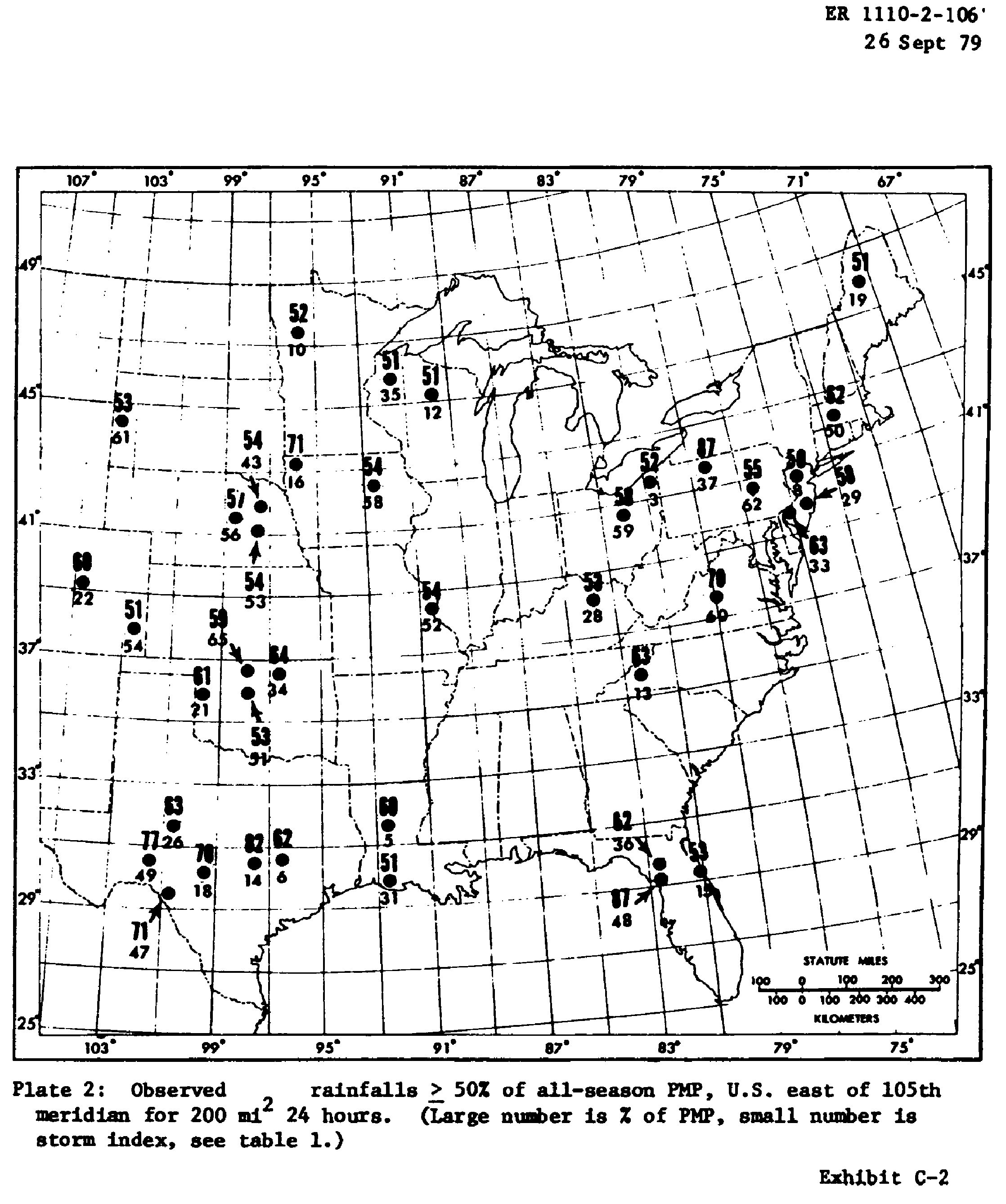
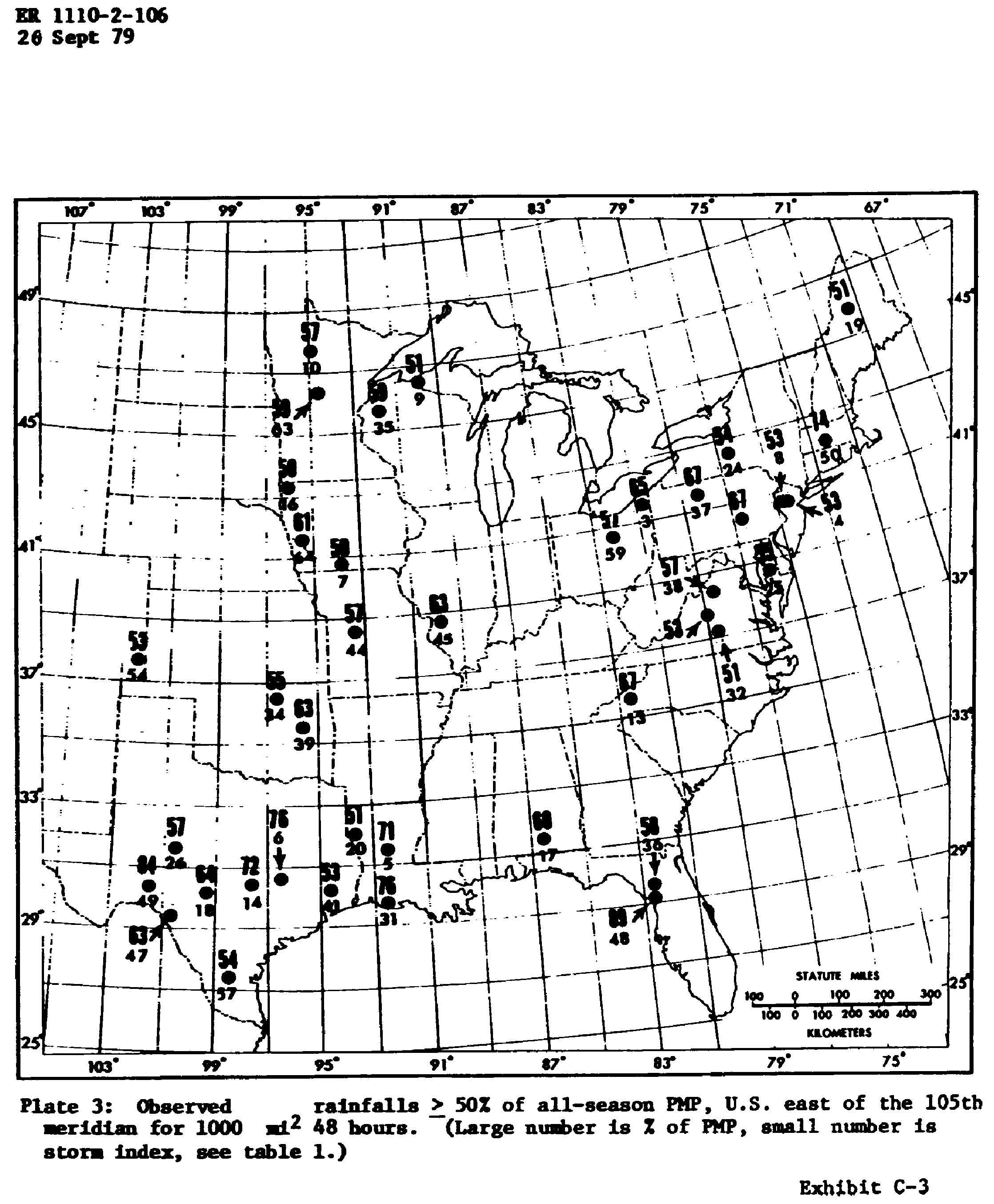
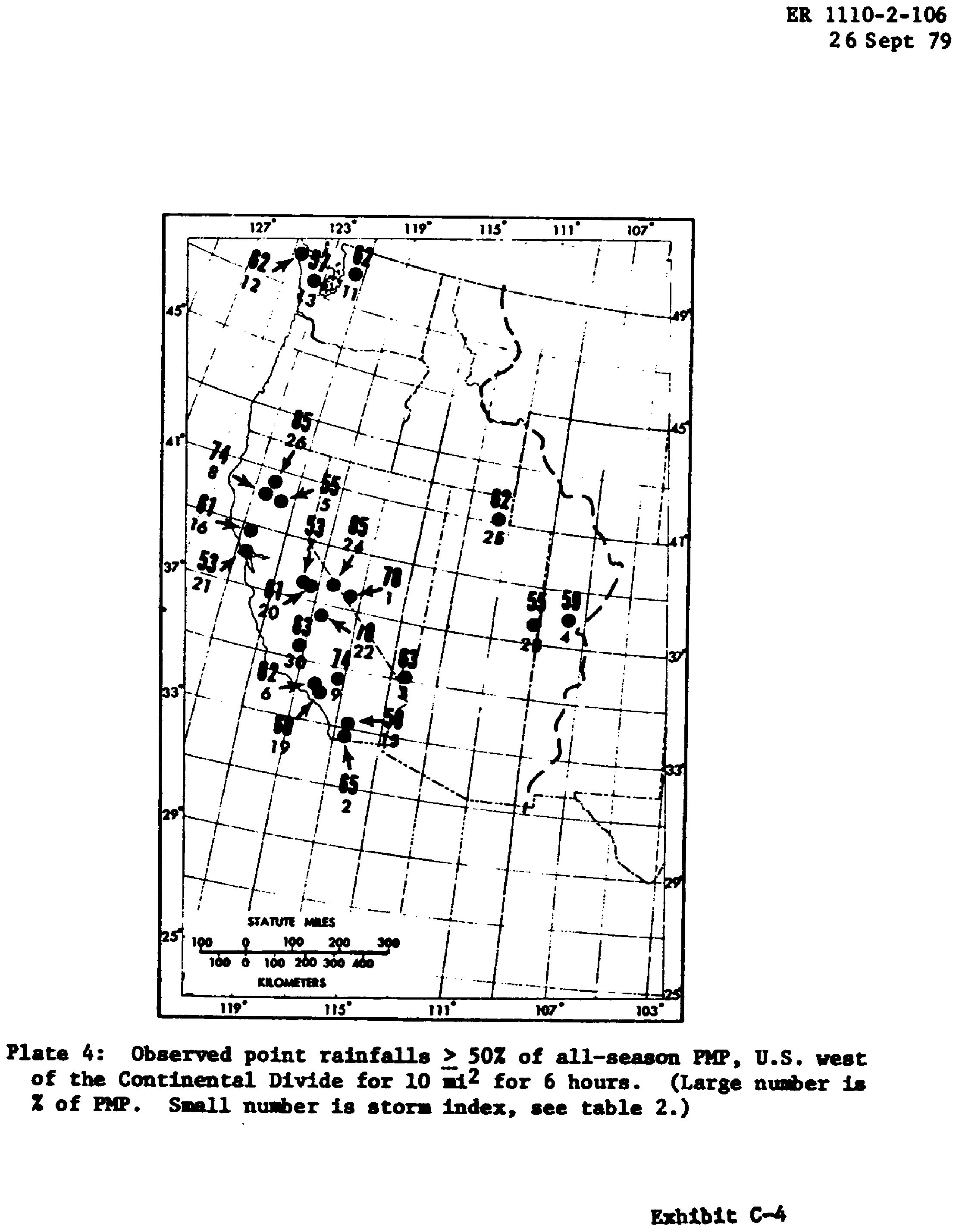
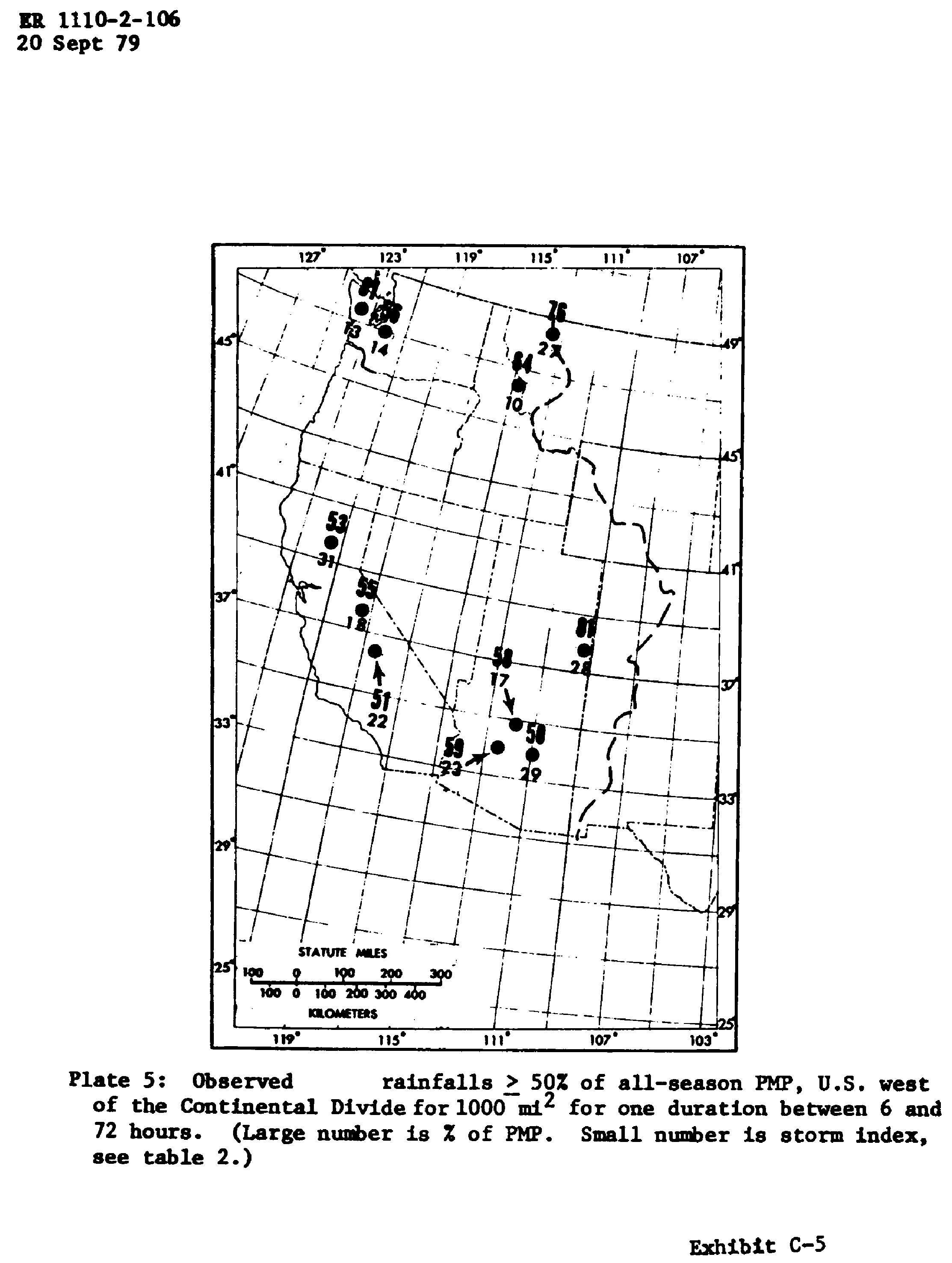
7. The Hydrometeorological Branch (HMB) of the National Weather Service has reviewed some 500 experienced large storms in the United States. The purpose of the review was to ascertain the relative magnitude of experienced large storms to probable maximum precipitation (PMP) and their distribution throughout the country. Their review reveals that about 25 percent of the major storms have exceeded 50 percent of the probable maximum precipitation for one or more combinations of area and duration. In fact some storms have very closely approximated the PMP values. Exhibits C–1 thru C–5 indicate locations where experienced storms have exceeded 50 percent of the PMP.
8. There are several options to consider when selecting mitigation measures to avoid severe consequences of a dam failure from overtopping. The following measures may be required by a Governor when sufficient legal authority is available under State laws and a dam presents a serious threat to loss of life.
a. Remove the dam.
b. Increase the height of dam and/or spillway size to pass the probable maximum flood without overtopping the dam.
c. Purchase downstream land that would be adversely impacted by dam failure and restrict human occupancy.
d. Enhance the stability of the dam to permit overtopping by the probable maximum flood without failure.
e. Provide a highly reliable flood warning system (generally does not prevent damage but avoids loss of life).
|
TABLE 1—STORMS WITH RAINFALL ≥ 150% OF PMP, U.S. EAST OF THE 105TH MERIDIAN (FOR 10 MI [FN2], 6 HOURS; 200 MI [FN2], 24 HOURS AND/OR 1,000 MI [FN2], 48 HOURS) |
||||||
|---|---|---|---|---|---|---|
|
Storm center |
||||||
|
Storm date |
Index No. |
Corps assignment No. (if available) |
Town |
State |
Latitude |
Longitude |
|
July 26, 1819 |
1 |
Catskill |
NY |
42°12′ |
73°53′ |
|
|
Aug. 5, 1843 |
2 |
Concordville |
PA |
39°53′ |
75°32′ |
|
|
Sept. 10-13, 1878 |
3 |
OR 9-19 |
Jefferson |
OH |
41°45′ |
80°46′ |
|
Sept. 20-24, 1882 |
4 |
NA 1-3 |
Paterson |
NJ |
40°55′ |
74°10′ |
|
June 13-17, 1886 |
5 |
LMV 4-27 |
Alexandria |
LA |
31°19′ |
92°33′ |
|
June 27-July 11, 1899 |
6 |
GM 3-4 |
Turnersville |
TX |
30°52′ |
96°32′ |
|
Aug. 24-28, 1903 |
7 |
MR 1-10 |
Woodburn |
IA |
40°57′ |
93°35′ |
|
Oct. 7-11, 1903 |
8 |
GL 4-9 |
Paterson |
NJ |
40°55′ |
74°10′ |
|
July 18-23, 1909 |
9 |
UMV 1-11B |
Ironwood |
MI |
46°27′ |
90°11′ |
|
July 18-23, 1909 |
10 |
UMV 1-11A |
Beaulieu |
MN |
47°21′ |
95°48′ |
|
July 22-23, 1911 |
11 |
Swede Home |
NB |
40°22′ |
96°54′ |
|
|
July 19-24, 1912 |
12 |
GL 2-29 |
Merrill |
WI |
45°11′ |
89°41′ |
|
July 13-17, 1916 |
13 |
SA 2-9 |
Altapass |
NC |
35°33′ |
82°01′ |
|
Sept. 8-10, 1921 |
14 |
GM 4-12 |
Taylor |
TX |
30°35′ |
97°18′ |
|
Oct. 4-11, 1924 |
15 |
SA 4-20 |
New Smyrna |
FL |
29°07′ |
80°55′ |
|
Sept. 17-19, 1926 |
16 |
MR 4-24 |
Boyden |
IA |
43°12′ |
96°00′ |
|
Mar. 11-16, 1929 |
17 |
UMV 2-20 |
Elba |
AL |
31°25′ |
86°04′ |
|
June 30-July 2, 1932 |
18 |
GM 5-1 |
State Fish Hatchery |
TX |
30°01′ |
99°07′ |
|
Sept. 16-17, 1932 |
19 |
Ripogenus Dam |
ME |
45°53′ |
69°09′ |
|
|
July 22-27, 193 |
20 |
LMV 2-26 |
Logansport |
LA |
31°58′ |
94°00′ |
|
Apr. 3-4 1934 |
21 |
SW 2-11 |
Cheyenne |
OK |
35°37′ |
99°40′ |
|
May 30-31, 1935 |
22 |
MR 3-28A |
Cherry Creek |
CO |
39°13′ |
104°32′ |
|
May 31, 1935 |
23 |
GM 5-20 |
Woodward |
TX |
29°20′ |
99°28′ |
|
July 6-10, 1935 |
24 |
NA 1-27 |
Hector |
NY |
42°30′ |
76°53′ |
|
Sept. 2-6, 1935 |
25 |
SA 1-26 |
Easton |
MD |
38°46′ |
76°01′ |
|
Sept. 14-18, 1936 |
26 |
GM 5-7 |
Broome |
TX |
31°47′ |
100°50′ |
|
June 19-20, 1939 |
27 |
Snyder |
TX |
32°44′ |
100°55′ |
|
|
July 4-5, 1939 |
28 |
Simpson |
KY |
38°13′ |
83°22′ |
|
|
Aug. 19, 1939 |
29 |
NA 2-3 |
Manahawkin |
NJ |
39°42′ |
74°16′ |
|
June 3-4, 1940 |
30 |
MR 4-5 |
Grant Township |
NB |
42°01′ |
96°53′ |
|
Aug. 6-9, 1940 |
31 |
LMV 4-24 |
Miller Isl |
LA |
29°45′ |
92°10′ |
|
Aug. 10-17, 1940 |
32 |
SA 5-19A |
Keysville |
VA |
37°03′ |
78°30′ |
|
Sept. 1, 1940 |
33 |
NA 2-4 |
Ewan |
NJ |
39°42′ |
75°12′ |
|
Sept. 2-6, 1940 |
34 |
SW 2-18 |
Hallet |
OK |
36°15′ |
96°36′ |
|
Aug. 28-31, 1941 |
35 |
UMV 1-22 |
Haywood |
WI |
46°00′ |
91°28′ |
|
Oct. 17-22, 1941 |
36 |
SA 5-6 |
Trenton |
FL |
29°48′ |
82°57′ |
|
July 17-18, 1942 |
37 |
OR 9-23 |
Smethport |
PA |
41°50′ |
78°25′ |
|
Oct. 11-17, 1942 |
38 |
SA 1-28A |
Big Meadows |
VA |
38°31′ |
78°26′ |
|
May 6-12, 1943 |
39 |
SW 2-20 |
Warner |
OK |
35°29′ |
95°18′ |
|
May 12-20, 1943 |
40 |
SW 2-21 |
Nr. Mounds |
OK |
35°52′ |
96°04′ |
|
July 27-29, 1943 |
41 |
GM 5-21 |
Devers |
TX |
30°02′ |
94°35′ |
|
Aug. 4-5, 1943 |
42 |
OR 3-30 |
Nr. Glenville |
WV |
38°56′ |
80°50′ |
|
June 10-13, 1944 |
43 |
MR 6-15 |
Nr. Stanton |
NB |
41°52′ |
97°03′ |
|
Aug. 12-15, 1946 |
44 |
MR 7-2A |
Cole Camp |
MO |
38°40′ |
93°13′ |
|
Aug. 12-16, 1946 |
45 |
MR 7-2B |
Nr. Collinsville |
IL |
38°40′ |
89°59′ |
|
Sept. 26-27, 1946 |
46 |
GM 5-24 |
Nr. San Antonio |
TX |
29°20′ |
98°29′ |
|
June 23-24, 1948 |
47 |
Nr. Del Rio |
TX |
29°22′ |
100°37′ |
|
|
Sept. 3-7, 1950 |
48 |
SA 5-8 |
Yankeetown |
FL |
29°03′ |
82°42′ |
|
June 23-28, 1954 |
49 |
SW 3-22 |
Vic Pierce |
TX |
30°22′ |
101°23′ |
|
Aug. 17-20, 1955 |
50 |
NA 2-22A |
Westfield |
MA |
42°07′ |
72°45′ |
|
May 15-16, 1957 |
51 |
Hennessey |
OK |
36°02′ |
97°56′ |
|
|
June 14-15, 1957 |
52 |
Nr. E. St. Louis |
IL |
38°37′ |
90°24′ |
|
|
June 23-24, 1963 |
53 |
David City |
NB |
41°14′ |
97°05′ |
|
|
June 13-20, 1965 |
54 |
Holly |
CO |
37°43′ |
102°23′ |
|
|
June 24, 1966 |
55 |
Glenullin |
ND |
47°21′ |
101°19′ |
|
|
Aug. 12-13, 1966 |
56 |
Nr. Greely |
NB |
41°33′ |
98°32′ |
|
|
Sept. 19-24, 1967 |
57 |
SW 3-24 |
Falfurrias |
TX |
27°16′ |
98°12′ |
|
July 16-17, 1968 |
58 |
Waterloo |
IA |
42°30′ |
92°19′ |
|
|
July 4-5, 1969 |
59 |
Nr. Wooster |
OH |
40°50′ |
82°00′ |
|
|
Aug. 19-20, 1969 |
60 |
NA 2-3 |
Nr. Tyro |
VA |
37°49′ |
79°00′ |
|
June 9, 1972 |
61 |
Rapid City |
SD |
44°12′ |
103°31′ |
|
|
June 19-23, 1972 |
62 |
Zerbe |
PA |
40°37′ |
76°31′ |
|
|
July 21-22, 1972 |
63 |
Nr. Cushing |
MN |
46°10′ |
94°30′ |
|
|
Sept. 10-12, 1972 |
64 |
Harlan |
IA |
41°43′ |
95°15′ |
|
|
Oct. 10-11, 1973 |
65 |
Enid |
OK |
36°25′ |
97°52′ |
|
TABLE 2—STORMS WITH RAINFALL ≥50% OF PMP, U.S. WEST OF CONTINENTAL DIVIDE (FOR 10 MI [FN2] 6 HOURS OR 1,000 MI [FN2] FOR ONE DURATION BETWEEN 6 AND 72 HOURS) |
||||||
|---|---|---|---|---|---|---|
|
Storm center |
||||||
|
Storm date |
Index No. |
Town |
State |
Latitude |
Longitude |
Duration for 1,000 mi2 |
|
Aug. 11, 1890 |
1 |
Palmetto |
NV |
37°27′ |
117°42′ |
|
|
Aug. 12, 1891 |
2 |
Campo |
CA |
32°36′ |
116°28′ |
|
|
Aug. 28, 1898 |
3 |
Ft. Mohave |
AZ |
35°03′ |
114°36′ |
|
|
Oct. 4-6, 1911 |
4 |
Gladstone |
CO |
37°53′ |
107°39′ |
|
|
Dec. 29, 1913-Jan. 3, 1914 |
5 |
CA |
39°55′ |
121°25′ |
||
|
Feb. 17-22, 1914 |
6 |
Colby Ranch |
CA |
34°18′ |
118°07′ |
|
|
Feb. 20-25, 1917 |
7 |
CA |
37°35′ |
119°36′ |
||
|
Sept. 13, 1918 |
8 |
Red Bluff |
CA |
40°10′ |
122°14′ |
|
|
Feb. 26-Mar 4, 1938 |
9 |
CA |
34°14′ |
117°11′ |
||
|
Mar. 30-Apr. 2, 1931 |
10 |
ID |
46°30′ |
114°50′ |
24 |
|
|
Feb. 26, 1932 |
11 |
Big Four |
WA |
48°05′ |
121°30′ |
|
|
Nov. 21, 1933 |
12 |
Tatoosh Is |
WA |
48°23′ |
124°44′ |
|
|
Jan. 20-25, 1935 |
13 |
WA |
47°30′ |
123°30′ |
6 |
|
|
Jan. 20-25, 1935 |
14 |
WA |
47°00′ |
122°00′ |
72 |
|
|
Feb. 4-8, 1937 |
15 |
Cyamaca Dam |
CA |
33°00′ |
116°35′ |
|
|
Dec. 9-12, 1937 |
16 |
CA |
38°51′ |
122°43′ |
||
|
Feb. 27-Mar. 4, 1938 |
17 |
AZ |
34°57′ |
111°44′ |
12 |
|
|
Jan. 19-24, 1943 |
18 |
CA |
37°35′ |
119°25′ |
18 |
|
|
Jan. 19-24, 1943 |
19 |
Hoegee's Camp |
CA |
34°13′ |
118°02′ |
|
|
Jan. 30-Feb. 3, 1945 |
20 |
CA |
37°35′ |
119°30′ |
||
|
Dec. 27, 1945 |
21 |
Mt. Tamalpias |
CA |
37°54′ |
122°34′ |
|
|
Nov. 13-21, 1950 |
22 |
CA |
36°30′ |
118°30′ |
24 |
|
|
Aug. 25-30, 1951 |
23 |
AZ |
34°07′ |
112°21′ |
72 |
|
|
July 19, 1955 |
24 |
Chiatovich Flat |
CA |
37°44′ |
118°15′ |
|
|
Aug. 16, 1958 |
25 |
Morgan |
UT |
41°03′ |
111°38′ |
|
|
Sept. 18, 1959 |
26 |
Newton |
CA |
40°22′ |
122°12′ |
|
|
June 7-8, 1964 |
27 |
Nyack Ck |
MT |
48°30′ |
113°38′ |
12 |
|
Sept. 3-7, 1970 |
28 |
UT |
37°38′ |
109°04′ |
6 |
|
|
Sept. 3-7, 1970 |
29 |
AZ |
33°49′ |
110°56′ |
6 |
|
|
June 7, 1972 |
30 |
Bakersfield |
CA |
35°25′ |
119°03′ |
|
|
Dec. 9-12, 1937 |
31 |
CA |
39°45′ |
121°30′ |
48 |
Cite this article: FindLaw.com - Code of Federal Regulations Title 33. Navigation and Navigable Waters § 33.222.6—Hydrologic and Hydraulic Assessment of Dams - last updated January 02, 2025 | https://codes.findlaw.com/cfr/title-33-navigation-and-navigable-waters/cfr-sect-33-222-6-app-c/
FindLaw Codes may not reflect the most recent version of the law in your jurisdiction. Please verify the status of the code you are researching with the state legislature before relying on it for your legal needs.
Get help with your legal needs
FindLaw’s Learn About the Law features thousands of informational articles to help you understand your options. And if you’re ready to hire an attorney, find one in your area who can help.
